


- Ohio Fast Facts -
(Temporary) Ohio Archivist : Ohio is most popularly known as "The Buckeye State" after its Ohio buckeye trees, a species of horse chestnuts. A popular candy that closely resembles
the nut is made by combining powdered sugar with peanut butter and dipping the rolled balls into melted chocolate, leaving a small circle of peanut butter
filling exposed. Other nicknames include "Birthplace of Aviation", "The Heart of it All" and "The Mother of Modern Presidents".
Ohio is most popularly known as "The Buckeye State" after its Ohio buckeye trees, a species of horse chestnuts. A popular candy that closely resembles
the nut is made by combining powdered sugar with peanut butter and dipping the rolled balls into melted chocolate, leaving a small circle of peanut butter
filling exposed. Other nicknames include "Birthplace of Aviation", "The Heart of it All" and "The Mother of Modern Presidents".
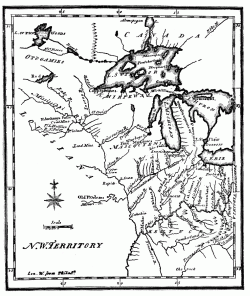 The region was first explored by Robert Cavelier, Sieur de la Salle for France. The Treaty of Paris ceded the region to Great Britain in 1763. The country was acquired
by the U.S. after the Revolutionary War and in 1788 the first permanent settlement was established at Marietta. Ohio became part of the Northwest Territory. On April 30, 1802
the Seventh Congress of the United States passed the Enabling Act of 1802 which gave residents of the eastern portion of the Northwest Territory to
form the state of Ohio. The Act defined Ohio's borders as follows:
The region was first explored by Robert Cavelier, Sieur de la Salle for France. The Treaty of Paris ceded the region to Great Britain in 1763. The country was acquired
by the U.S. after the Revolutionary War and in 1788 the first permanent settlement was established at Marietta. Ohio became part of the Northwest Territory. On April 30, 1802
the Seventh Congress of the United States passed the Enabling Act of 1802 which gave residents of the eastern portion of the Northwest Territory to
form the state of Ohio. The Act defined Ohio's borders as follows:
"Bounded on the east by the Pennsylvania line, on the south by the Ohio River, to the mouth of the Great Miami River, on the west by the line drawn due north
from the mouth of the Great Miami aforesaid, and on the north by an east and west line drawn through the southerly extreme of Lake Michigan, running east
after intersecting the due north line aforesaid, from the mouth of the Great Miami until it shall intersect Lake Erie or the territorial line, and thence
with the same through Lake Erie to the Pennsylvania line aforesaid."
Ohio was admitted to the Union as the 17th state on March 1, 1803. Following a heated boundary dispute with Michigan over the "Toledo Strip" (1835-1836) Ohio's border with Michigan was changed to angle northeast to the northern shore of mouth of the Maumee River and gave Ohio the valuable shipping port of Toledo. Michigan, in turn, was granted the western portion of the Upper Peninusla. Through some oversight no formal declaration was made until President Dwight Eisenhower officially signed the documents making it a state in 1953. The document was made retroactive to the original date of 1803.
Today Ohio covers 44,825 square miles of land, has 88 counties and ranks 7th in population. The State Capitol and largest city is Columbus.
The genealogical records held here are for use by the general public. These records have been submitted to the USGenNet Data Repository by volunteers and researchers just like you for permanent on-line free-access.