

- St. Clair County -
 St. Clair county is the easternmost county in Michigan and is one of five counties that form the "thumb" of Michigan. When set off from Wayne county
and created by proclamation of Governor Cass, on March 28, 1820, it had an area about four times as large as the present county. It included a large
part of Sanilac, Lapeer, Tuscola, Genesee and Shiawassee counties along with small parts of Macomb, Saginaw and Huron counties. The present county has
a total area of 837 square miles of which 115 square miles is water. It is bounded on the north by Sanilac county, the west by Lapeer, the south by
Macomb and Lake St. Clair, and the east by the St. Clair River which forms part of an international border with Ontario, Canada.
St. Clair county is the easternmost county in Michigan and is one of five counties that form the "thumb" of Michigan. When set off from Wayne county
and created by proclamation of Governor Cass, on March 28, 1820, it had an area about four times as large as the present county. It included a large
part of Sanilac, Lapeer, Tuscola, Genesee and Shiawassee counties along with small parts of Macomb, Saginaw and Huron counties. The present county has
a total area of 837 square miles of which 115 square miles is water. It is bounded on the north by Sanilac county, the west by Lapeer, the south by
Macomb and Lake St. Clair, and the east by the St. Clair River which forms part of an international border with Ontario, Canada.
How the county got its name is a matter of conjecture. It was on August 12, 1679, the feast day of Sainte Clare of Assisi, that René Robert Cavelier, Sieur de La Salle, sailed the famed barque Le Griffon onto the waters of Lake St. Clair and named it as Lac Sainte-Clare in honor of her. Some attribute the name to Major General Arthur St. Clair, Governor of the Northwest Territory. Others attribute the name to Patrick Sinclair, an Irish officer in the British service, who purchased 3,759 acres of land along the river in 1765.
 In 1686 a military station, built by Daniel Graysolon Du Luth under the direction of Denouville, was established near the point where Fort Gratiot is now located. This post was called St. Joseph, and
was occupied until the fall of 1678, when it was abandoned. No further settlement of this area was attempted for over 100 years. In about 1790
Anslem Petit and six other Frenchmen with their families settled here. Edward Petit was the first white child born in the settlement.
In 1686 a military station, built by Daniel Graysolon Du Luth under the direction of Denouville, was established near the point where Fort Gratiot is now located. This post was called St. Joseph, and
was occupied until the fall of 1678, when it was abandoned. No further settlement of this area was attempted for over 100 years. In about 1790
Anslem Petit and six other Frenchmen with their families settled here. Edward Petit was the first white child born in the settlement.
The earliest settlers in the county all located on its eastern and southern edge, on the river or lake, which were the only means of transportation at the time. This blue water highway, in conjunction with vast expanses of timber which made it one of the greatest lumber markets in the west, also provided an excellent location for ship building. Towns like Algonac, Port Huron, St. Clair and Marine City grew up around these industries.
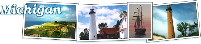
Fort Gratiot was established in 1814 to guard the juncture of Lake Huron and the St. Clair River, which had long been believed to be strategically important. Urged by a surge in vessel traffic Congress appropriated $3,500 to construct a lighthouse near Fort Gratiot on March 3, 1823. The light was first lit on August 8, 1825, making the Fort Gratiot Light the first lighthouse in Michigan. Today it remains the oldest surviving lighthouse in the state.
In 1938 the Blue Water bridge was built over the St. Clair River, connecting the cities of Port Huron and Sarnia, Ontario, to facilitate transportation between the United States and Canada. In 1997 a second bridge was built alongside the original to support eastbound traffic and ease congestion at the popular crossing.