- Huron County -
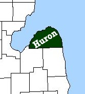 Huron county was laid out in
1840 and was organized in 1859. The county was named for the lake bordering on the north, east and west, and the lake,
in turn, was so called from a tribe of Indians called the Hurons, who lived there. Huron county is located in the
eastern part of the Lower Peninsula in what is known as the "Thumb" district. It is surrounded on three sides by water. Saginaw Bay forms the western boundary
while Lake Huron forms the northern and eastern boundary, giving Huron county over 90 miles of shoreline. Harbor
Beach, on the eastern side of the "thumb," boasts the largest man-made fresh water harbor in the world. Pointe Aux Barques, at the
northern tip of the county, is claimed by some to be the most dangerous spot on the Great Lakes as at least 80 vessels have been wrecked within twenty miles of it.
Huron county was laid out in
1840 and was organized in 1859. The county was named for the lake bordering on the north, east and west, and the lake,
in turn, was so called from a tribe of Indians called the Hurons, who lived there. Huron county is located in the
eastern part of the Lower Peninsula in what is known as the "Thumb" district. It is surrounded on three sides by water. Saginaw Bay forms the western boundary
while Lake Huron forms the northern and eastern boundary, giving Huron county over 90 miles of shoreline. Harbor
Beach, on the eastern side of the "thumb," boasts the largest man-made fresh water harbor in the world. Pointe Aux Barques, at the
northern tip of the county, is claimed by some to be the most dangerous spot on the Great Lakes as at least 80 vessels have been wrecked within twenty miles of it.
The first white settlers, lumbermen, came to Huron county in 1838 and were soon followed by fishermen. The lands cleared by lumbering operations were taken up by farmers and agriculture became the leading industry. Sand Beach (now Harbor Beach) was the county seat until 1865 when the court house burned. It was then moved to Port Austin and again moved to Bad Axe in 1873.
Huron county has a total area of 2,137 square miles, of which 61% is water.